To access this area we turned east off the Arthur Highway, 5.2km south of Murdunna into a forestry road with a sign marked 'Forestier State Forest'. We then drove 1.9km to a forestry gate, it was here that we parked the car and began our trek.

Both Jane and I started off enthusiastically, eager to get to the first landmark being the MacGregor Fire Tower. Our enthusiasm waned very quickly after starting the 30 minute walk. The track was very steep and very rocky, infact exceedingly steep and rocky! I was thinking about how many hours on the treadmill I'd need to get a cardio workout like this one and Jane was thinking, as she later admitted, what sort of walk is this mad woman taking me on. Needless to say there was not much talking done for the next half hour, neither of us had any breathe left to waste on talking. This was hard yakka!
Finally, we reach flat ground....ahh relief...not for long though as the track now narrows and climbs steeply, but for only about 100 metres to the Fire Tower.


From the firetower the walking track heads east and is marked by a mixture of orange pointers and small rock cairns. Unfortunately the pointers are very infrequent and at times hard to spot so looking out for them does detract a little from appreciating the beautiful surrounds. This area is dominated by Stringbark and Blue Gum, scattered Bedfordia and a few patches of young Sassafras. The track which is over rocky ground swings southeast and enters a closed forest (a forest with a tree canopy of 60 to 100%). For the first time on any of my walks we come across a black snake...minding his own business sunning himself on the track. Under the circumstances all 3 of us remained relatively calm, the snake slithered away under a rock and Jane and I took a wide berth around the area just in case. After this encounter we were mindful of the need to remain on alert for unexpected wildlife sharing the track.
The route continues to an area locally know as the Magic Forest and it's not difficult to see why. The track winds through a very old forest of Sassafras, Musk and Native Laurel, which have gnarled and twisted trunks and branches, while Treeferns and the endemic Grass Trees grow among large moss covered rocks. Funghi of all shapes, sizes and colours grow on the ground and fallen logs, and even on the living trees. The whole scene is bathed in an almost iridescent green light...it is truly magical.


The track at this point is dominated by alot of boulder climbing which once again gets the heart rate up. Another thing I noticed as we were walking along, probably because I was leading the way, is there are so many spider webs...now this doesn't normally worry me but walking through thick webs every few metres can get a bit freaky, I was starting to get paranoid as to whether the occupants of these webs were using me as some sort of free public transport service...regular checks found this wasn't the case...thank goodness!
One hour from the firetower the track reaches a trig point at the true summit of MacGregor Peak, 591 metres above sea level, it's here that we stop for our first prolonged refreshment break.

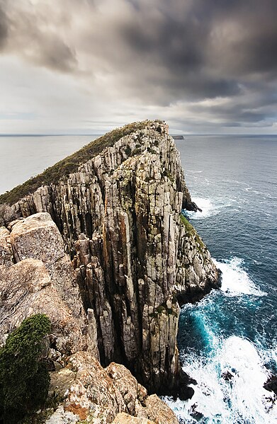
A few metres to the south of the trig marker, a large rock provides views to Tasman Island, Cape Pillar, Hippolyte Rock, Cape Hauy and Norfolk Bay. This is the premium spot on the hike for scenic vistas.
 |
| Cape Pillar, Hippolytes & Cape Hauy |
 |
| Pirates Bay |
 |
| Jane getting a few shots |
We follow the track for another 25 minutes or so and then it descends off the ridge and enters the largest tract of remnant rainforest on the east coast. This is a truly impressive forest, being dominated by massive Sassafras and Musk, the occasional Celery-top Pine and some of the largest Treeferns on the Peninsula. The ground is a mass of twisted roots, and mosses and ferns grow abundantly. A word of caution though, the markers become very unclear and very intermittent.....we spent a lot of time getting through this area. In the name of safety do not proceed on until you have sighted the next marker as the track is very unclear and it would be very easy to become disoriented and ultimately lost....unless that's just me! How we approached this situation was for one of us to stay at the last known marker while the other went in search of the next marker.....never wandering too far away, always in a straight line and always staying within ear shot of the other person. For this reason alone it would be very foolish to go on any of these walks by yourself....at this point we had also lost mobile reception.
The descent off the ridge is, as expected, very steep and is through mixed forest. Mixed forest is a type of Cool Temperate Rainforest, where trees grow as an understorey amongst old growth giants, it is very rare and only occurs in areas that have not had fire for a very long time. Unfortunately, there are signs of old selective logging activity, with some very large old stumps and the remains of a shoe track where logs were dragged across the forest floor.
Approximately an hour from the summit, the walking track intersects the four wheel drive track "Schofields Road". It's at this point we stop for lunch. It wasn't the most relaxing lunch spot, as there was the constant need to check ourselves for leeches which seemed to be quite abundant in this area.
Once we finish lunch we head down the 4WD track through regrowth wet forest...wet forest has an understorey in which broad-leaved tall shrubs and small trees such as Dogwood, Musk and Bedfordia form a prominent layer. The shrub understorey is often very dense. After a 25 minute walk we come to a forestry gate, which isn't very obvious as quite a bit of foliage has grown over it and obscured it from view. Just beyond the gate is a jeep track which leads to the left. Follow this track as it climbs (quite steeply) to a saddle in the Fazackerleys Range. Apparently, the track passes an old quarry site, however we didn't spot it so can only conclude that it has been many, many years since it's been worked and has now become overgrown.
After a further 30 minute walk we reach another forestry gate and lo and behold end up at the spot where we left the car 6 and a half hours earlier! So, the Fazackerleys Range Circuit had been successfully completed, taking longer than anticipated, due mainly to the condition of the track and the need to be sure of keeping on the correct route. While we didn't experience the breathtaking views that have been a feature of previous hikes, this one held it's own allurement by passing through some of the most breathtaking scenery you could wish to encounter. Researching the different types of forests and their makeup has also appealed to my inner geek...I'm learning so much, and hope that the readers of this blog find the little bits of info interesting as well.
Well, I have managed to return another walking partner safely back to civilisation, and Jane has even expressed an enthusiastic interest in accompanyng me on another hike in the future...yay! Not sure if she was swayed by the obligatory refreshment break at the Dunalley pub on the way home, or the mutual enjoyment we shared from spending the day in such a magnificent location, but I will definitely be taking her up on the offer.
So once again a day has been spent in magnificent surrounds and with a fantastic walking companion. Bushwalking should be fun, so when you set out don't put pressure on yourself to achieve the times given on signs and don't be afraid to turn back if the walk seems too difficult. We are blessed with some of the most beautiful scenery in the State and I'm sure if you decide to undertake these walks you will find them, like I have, to be irresistable!
 I can't think of any better way to have spent Valentine's Day......well perhaps there's one other better way but this comes in at a very close second!!
 |
| Giant Treefern |